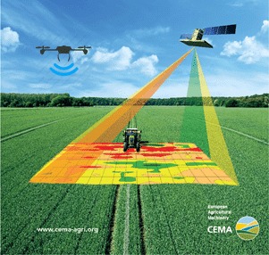
ISLAMABAD: A better understanding of crops can be achieved through geospatial monitoring, which can help improve the overall yields, says an expert.
Dr Ghani Akbar, Principal Scientific Officer at National Agriculture Research Centre (NARC), said while talking to WealthPK that geospatial technology is an emerging field that includes Geographic Information System (GIS) technology as well as Remote Sensing (RS) and Global Positioning System (GPS) technology.
“Using geospatial technology, we can acquire data that is based on the earth, and use this data to analyse, model, simulate, and visualise,” he said.
Geospatial technology is mainly used for surveying and mapping plantation crops. The purpose of the systems is to capture, store, manipulate, analyse, manage, and present all types of geographical information in one place.
“The objective of this project is to assist producers of agrochemicals in assessing the fate of their crops through research, transportation, toxicity, field investigations and spatial analysis,” Dr Ghani said.
There are estimates that the world’s population will reach 9.1 billion by the 2050, the majority of this growth will occur in developing countries. The urbanisation rate and income level will increase simultaneously. It will be necessary to increase the food production by 70% in order to feed this larger urbanised population. And the only way to achieve that is to introduce more technology into agriculture.
“Geospatial monitoring of crops is one of the technologies that can transform the agriculture sector in the near future. The use of this technology in agriculture can make it more efficient, climate-smart, and nutrition-sensitive. It enables farmers to analyse soil data and determine what crops should be planted where and how to maintain soil nutrition with the help of soil data analysis,” he said.
Dr Ghani said geospatial technologies enable farmers to increase their production at reduced costs by managing land resources more efficiently.
In recent years, earth observation has evolved into a powerful technique for continuously monitoring the status of agriculture production on a wide range of spatial and temporal scales over time, as well as for identifying potential problems in the future.
By monitoring growth and analysing fields, satellites and UAVs can assist agriculturalists in detecting anomalies and optimising inputs.
With the use of sensors, the internet of things (IoT) based smart farming enables efficient monitoring of crop fields for factors such as light, humidity, temperature, and soil moisture. It is possible to automate irrigation systems with this technology, thus saving time, resources, and effort on fieldwork.


