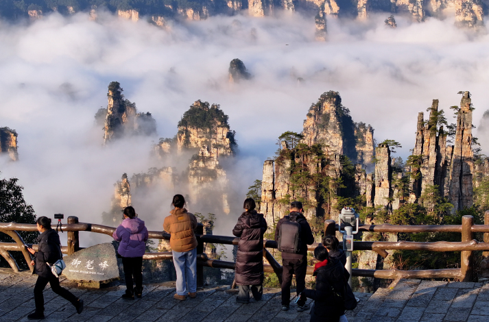
The Mount Changbaishan Geopark, along with five other Chinese geoparks, was recognized as a Global Geopark by the United Nations Educational, Scientific and Cultural Organization (UNESCO) on March 27.
The other five parks in China joining the Global Geoparks Network (GGN) are Enshi Grand Canyon-Tenglongdong Cave Geopark in Hubei Province, Linxia Geopark in Gansu Province, Longyan Geopark in Fujian Province, Wugongshan Geopark in Jiangxi Province, and Xingyi Geopark in Guizhou Province.
The number of Global Geoparks in China has been increased to 47, making it the country with the most such geoparks in the world. Now, there are a total of 213 Global Geoparks in 48 countries.

Development of geoparks
“China is rich in geological heritage, with a broad distribution and a complete range of geological types,” Ren Fang, an expert with the Chinese Academy of Geological Sciences, told People’s Daily. “It is one of the first countries in the world to propose and establish national geoparks administered by government departments.”
According to the National Forestry and Grassland Administration (NFGA), since 2002, China has allocated special funds annually for conservation projects in geological relic reserves and geoparks, leading to the preliminary establishment of a nationwide geopark system.
China set up national-level geoparks and began applying for Global Geopark status in 2003 in response to UNESCO’s initiative to establish the GGN. In 2004, the First International Conference on Geoparks was held in Beijing, where 17 European geoparks and eight Chinese geoparks joined the GGN. The network aims to promote best practices and high standards for the conservation of geological heritage and the promotion of sustainable regional economic development.
“Over the past 20 years, geoparks in China have evolved to become more comprehensive, from solely showcasing natural landscapes to integrating culture, history, and science education,” Ren said.
The Mount Changbaishan Geopark, newly added to the GGN network, is situated in Jilin Province in northeast China and is home to the “millennium eruption,” a massive volcanic event that occurred roughly 1,000 years ago. The eruption had a profound impact on the landscape, leaving behind pyroclastic deposits of international importance.
Renowned for its Quaternary volcanic landforms, the park, spanning 2,723 square km, features giant compound volcanic cones, ancient eruptions and their deposits, debris canyons, and the majestic Tianchi crater lake. With over 380 craters, it boasts the highest number, greatest density, and widest distribution of volcanic rock types in East Asia.
“Mount Changbaishan (also known as the Changbai Mountain), has garnered attention from the global scientific community for the comprehensiveness of its volcanic landscape types and geological phenomena,” Pan Bo, a researcher from the China Earthquake Administration’s Institute of Geology, told China News Agency. “Over 80 percent of the types of volcanic landforms found around the world can be found in this mountain area.”
The Changbai Mountain Reserve was established in 1960. In 2009, it was recognized as a national geopark by the then Ministry of Land and Resources. The park has also upgraded the Changbaishan Museum of Natural History to better reflect its geological and cultural heritage, enhancing its role in educational tourism.
In 2020, the park’s administration embarked on a journey to join the list of UNESCO Global Geoparks, forming a dedicated team to survey its geology, building a database, and preparing application materials. Zhao Yueming, head of the park’s public relations department, revealed that over 33 million yuan ($4.5 million) was invested in the endeavor.
“The inclusion of this region into the GGN will promote the protection of the Changbai Mountain’s geological relics and further research on the park’s volcanoes,” Pan said.
Zhang Rongjie, head of the park’s science and education department, emphasized the ecological significance of the Changbai Mountain, home to 1,586 species of wild animals and 2,639 species of plants, including several species under protection. This rich biodiversity highlights the global importance of the park’s ecosystem conservation initiatives.
In their application to join the GGN, the team enhanced the Changbaishan Museum of Natural History by adding more geological elements, ore specimens, and folk culture exhibits. These additions were aimed at showcasing the area’s distinct geological and cultural features.
Furthermore, the park initiated educational programs focused on geological science for local schools, engaging over 710 students and reinforcing its dedication to educational outreach.

Protection and beyond
“Over the past two decades, China’s geoparks have concentrated not only on the protection and rational utilization of resources but have also strived to achieve a balance between development and conservation,” said Ren Fang from the Chinese Academy of Geological Sciences.
She explained that the strategy has evolved from merely narrating the Earth’s story to a comprehensive integration of geopark resources. Geoparks have encouraged local residents to partake in their development, with an increasing number of locals reaping economic benefits from geotourism. This engagement has significantly boosted their wellbeing and cultural pride.
For instance, the Zhangye Geopark in Gansu has been instrumental in aiding rural residents in overcoming poverty. Since its inclusion in the GGN in 2020, the park has initiated several poverty-alleviation projects combining tourism with ethnic customs, historical culture, and science education. It has crafted specific tour routes that extend beyond traditional sightseeing to include science education, study tours, ecotourism and festival tourism. In 2023, the park welcomed over 2.9 million visitors, providing a new avenue for local prosperity.
Geoparks have also embraced advanced technologies to enhance the dissemination of geological knowledge. The Yimengshan Geopark in Shandong Province, recognized as a Global Geopark in 2019, has started online live broadcasts, employing cutting-edge technologies like virtual reality to vividly present complex geological concepts to audiences.
In January 2024, the NFGA introduced management measures for Global Geoparks, laying down a fundamental framework for their standardized, orderly, and sustainable growth.
“Through meticulous scientific planning and management, we have established a database for the protection of geological relics within geoparks, enabling more focused and systematic conservation efforts and achieving sustainable development,” Ren said. “China has effectively forged a model of protection and utilization for its Global Geoparks, tailored to local conditions and unique characteristics.”
New Global Geoparks in China
Enshi Grand Canyon-Tenglongdong Cave Geopark
The geopark lies in the southwest of Hubei Province. It is home to world famous erosion and dissolution landscapes and the rich cultural heritage of the Tujia, Miao and Dong ethnic groups.
The geopark’s geological marvels unfold across exposed strata ranging from the Cambrian to the Cretaceous period (ca. 539 to 66 million years ago). The topography is deeply dissected by the Qingjiang River system, forming a spectacular karst landscape in Permian and Triassic carbonate rocks characterized by steep cliffs, deep gorges, caves and disappearing rivers. The geological landscape supports remarkable biodiversity, with lush forests covering an astounding 67.3 percent of the geopark, an area of over 450 square km. There are more than 4,000 plant species and 500 different terrestrial vertebrates in the geopark.
Beyond the geopark’s geological splendor, the rich cultural heritage of the Tujia, Miao and Dong ethnic groups lies at the heart of the territory. Visitors can experience traditional architecture, folk songs, dances and festivals which enrich their understanding of the region’s cultural fabric.
Linxia Geopark
The geopark is located in Gansu Province. It features a landscape characterized by mid-high mountains, hills and basins. The area played a significant role in China’s early historical and cultural development.
The dramatic Danxia landform along the Yellow River showcases striking colorful rock formations shaped by erosion, weathering and gravity. The geopark is home to the famous Bingling Cave Temple grottoes, where intricate sculptures are carved into the cliff faces, and to one of the longest and best-preserved fossil trackways on record, 24 consecutive paired footprints of the pterosaur, the earliest vertebrate species known to have evolved powered flight. The geopark is the region with most abundant ancient mammal fossils in China.
With roots tracing back more than 5,000 years along the Yellow River, Linxia was an important courier station along the ancient Silk Road.
Longyan Geopark
The geopark offers a geological record of tectonic evolution in southeast China covering a period of approximately 300 million years. The geopark’s abundant geological heritage includes the Meihuashan granitic complex, the Guanzhaishan red bed sedimentary rocks and the Zijinshan super-large porphyry-epithermal copper–gold deposit.
Home to the densest natural forests of west Fujian Province, the geopark displays rich biodiversity. It is home to endemic animal and plant species, including the Panthera tigris amoyensis (South China tiger) and the rare Taxus chinensis var. Mairei (Chinese yew).
Longyan is the birthplace of the Hakka culture. Many unique traditions endure to the present day, including the you da long, where locals dance in a large dragon formation, the zou gu shi, where locals wear traditional clothes and take part in a carnival, and the art of woodblock printing. The Peitian Landscape Roundhouses display the architectural style of the Hakka culture, arranged compactly along long cobbled streets.
Mount Changbaishan Geopark
Located in southeast Jilin Province, the geopark is like an open-air classroom for volcanology, with dramatic landforms and diverse rock types that document significant multiphase eruptions. The “millennium eruption,” which took place around 1,000 years ago, is one of the largest volcanic eruptions in human history and has left a lasting impact, creating special pyroclastic accumulations of international significance.
Mount Changbaishan itself is one of the best-preserved composite volcanoes from the past several million years. At its summit, you will find the highest and largest crater lake in northeast Asia, the Tianchi Lake, which offers breathtaking views.
The geopark works closely with local communities to promote sustainable tourism and facilitate environmental restoration projects.
Wugongshan Geopark
The geopark is located at the junction of three cities, Pingxiang, Yichun and Ji’an, in the west of Jiangxi Province. It is characterized by fascinating geological landscapes including Jurassic (ca. 201 to 145 million years ago) granite stone forests, alpine meadows growing on the weathered Silurian (ca. 444 to 419 million years ago) granitic gneiss and hot springs. The geopark is rich in well-preserved geological heritage, making it a crucial site for studying the early formation of the South China Block and subsequent intracontinental compression and extension.
The geopark has developed a host of creative initiatives to promote geotourism, in order to strengthen the connection between local communities and the unique landscape. The large-scale tent festivals attract thousands of campers and promote outdoor activities such as mountain bike racing and bonfire carnivals. Another way to experience the landscape is by taking an agricultural tour of orchards and tea gardens, with a particular focus on picking.
Xingyi Geopark
Located in Guizhou Province, the geopark is a geological treasure trove with imposing natural scenery such as the Malinghe River Gorge, bursting with over 100 cascading waterfalls during periods of heavy rain. The Wanfenglin site displays more than 20,000 karst peaks, stretching as far as the eye can see, and was chosen as one of the four scenic spots in China to be honored on a postage stamp in 2013.
The geopark is world famous for the exceptionally preserved Xingyi fauna from the late Ladinian Age (ca. 242 to 237 million years ago). These marine reptile and fish fossils offer an unparalleled glimpse into the transition of marine life from nearshore habitats to the deep ocean. It is the only paleo-fauna site to preserve entirely the turnover of marine reptiles from the Ladinian Age to the Carnian Age (ca. 237 to 227 million years ago).
The geopark is home to ethnic groups including the Bouyei, Miao, Yi, Hui, Gelo and Shui. Among them, the Bouyei people are predominant, known for their expertise in weaving, batik printing, brocade work and embroidery.
Current projects in the geopark include the Wanfu Qixing Bee Farm Cooperative, which supports individuals with disabilities and their families through the production and sale of honey, and the Luyuan Flower Base, a center focused on research, cultivation and education related to orchids and other endangered plant species. There are over 2.5 million orchids and 50,000 endangered plants in the database. –The Daily Mail-Beijing Review news exchange item


